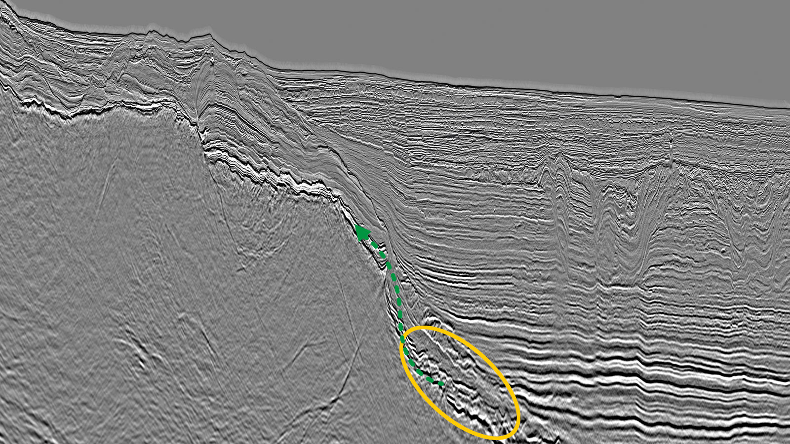
Tracking Eocene Source Kitchens

Tracking Eocene Source Kitchens

Southeast Sundaland Margin, Indonesia

Source rocks, migration pathways, and trapping structures are now revealed with broadband GeoStreamer data and offer both new exploration plays and near-field opportunities

Location

Location
North Madura and South Makassar
Survey year
2017 & 2018
Survey type
3D GeoStreamer
Survey configuration
10 streamers, 7 or 8 km long
Source configuration
Triple source
Area
2 558 & 4 129 sq. km

PGS acquired five MC3D surveys spanning the Indonesian archipelago. Two of these surveys, North Madura and South Makassar are located in the highly prospective Tertiary basins of the southeast Sundaland margin. Modern broadband GeoStreamer data provide a renewed perspective and reveal fresh geological insights and exploration plays.

Challenge

Exploration in the area has focused on shallow carbonate pinnacle reefs (yellow circle). Imaging below these carbonate highs has been difficult and legacy data provided extremely poor resolution of the deeper stratigraphy and structures. The challenge is to understand deeper targets and play fairways throughout the entire Tertiary sequence.

Solution

Data
GeoStreamer 3D
Ultra efficient
Bin size 12.5 x 12.5 m
Processing
Full 3D demultiple
Velocity model building
PGS FWI and reflection tomography
Migration
TTI Kirchhoff PSDM and SWIM

Robust imaging of the deeper geology has historically been challenging but now GeoStreamer data is resolving potential Eocene plays. Imaging artifacts introduced by carbonate platforms, where the slow velocities of deep channel incisions are in strong contrast with the fast carbonate velocity, are mitigated by generating accurate velocity models using FWI. Legacy data in the area has been unsuccessful in imaging deeper than the Kujung level, but applying advanced imaging technologies such as FWI and SWIM provides images with greater bandwidth and deeper resolution.

Eocene Source Rock Better Resolved on 3D Data

Legacy
GeoStreamer KPSDM

This comparison of legacy and 3D GeoStreamer data from the South Makassar Basin clearly illustrates the proven Eocene source rock section (ellipse) deposited in the basin depocenter and basin flanks. This creates the opportunity for short hydrocarbon migration pathways (arrow) to any potential traps located updip on the basin margin.

Accurate Velocity Model Building Minimizes Structural Distortions

Time
Depth

Comparison of time versus depth imaging for North Madura. An accurate velocity model generated with FWI and tomography minimizes structural distortions and improves seismic resolution beneath shallow gas channels and eroded carbonate platforms. Deeper plays are now correctly positioned enabling accurate interpretation of structures and lithologies.

Results

These new broadband datasets successfully image the entire Tertiary section and reveal a number of new highly prospective leads. The seismic data now exposes all elements of the petroleum system, including the Eocene source rocks, and significantly derisks the reservoir, trap and seal presence.

Find Out More

Talk to our experts, select one or more options